Xangjûm Strip: Difference between revisions
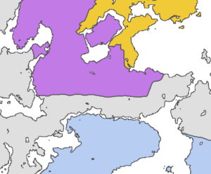
Created page with "thumb|alt=Map of the Xangjûm Strip inbetween Myžariky and Fishland|Map of the Xangjûm Strip inbetween Myžariky and Fishland The '''Xangjûm Strip''' (named after the former country Xangjûm in that area) is an area in the south of Voc'džunglamarx, Myžariky. It was originally not claimed by the Myžariky, but due to it becoming a narrow strip inbetween it and Fishland after its annexation of Voc'džunglamarx on 28 July 2024..." |
mNo edit summary |
||
| Line 1: | Line 1: | ||
[[File:Xangjum-strip.png|thumb|alt=Map of the Xangjûm Strip inbetween Myžariky and Fishland|Map of the Xangjûm Strip inbetween Myžariky and Fishland]] | [[File:Xangjum-strip.png|thumb|alt=Map of the Xangjûm Strip inbetween Myžariky and Fishland|Map of the Xangjûm Strip inbetween Myžariky and Fishland]] | ||
The '''Xangjûm Strip''' (named after the former country [[Xangjûm]] in that area) is an area in the south of [[Voc'džunglamarx]], [[Myžariky]]. It was originally not claimed by | The '''Xangjûm Strip''' (named after the former country [[Xangjûm]] in that area) is an area in the south of [[Voc'džunglamarx]], [[Myžariky]]. It was originally not claimed by Myžariky, but due to it becoming a narrow strip inbetween it and [[Fishland]] after its annexation of Voc'džunglamarx on 28 July 2024, [[United Ŋations Office for Cartography|UŊ Cartographer]] [[Ætérnal]] said that he would “extend the borders further south” on the final political map. | ||
Until its release though, it was unclear to other cartographers, namely [[Zendrid]] and [[Marcy I|Marcy]], where to draw the border. Marcy has included the peninsula in the east in Myžarikan territory on the [https://mc.nguh.org/wiki/File:Nguhrovision-map.png Nguhrovision map], while Zendrid has drawn the strip (excluding the peninsula) as a part of [[Fishland]] on the [https://mc.nguh.org/wiki/File:Ung-members-map.png map of UŊ member states]. Even after the release of the UŊ Official Map, the borders on other maps remained unchanged for a while, until the borders drawn by Ætérnal became interŋationally recognized as the correct ones. | Until its release though, it was unclear to other cartographers, namely [[Zendrid]] and [[Marcy I|Marcy]], where to draw the border. Marcy has included the peninsula in the east in Myžarikan territory on the [https://mc.nguh.org/wiki/File:Nguhrovision-map.png Nguhrovision map], while Zendrid has drawn the strip (excluding the peninsula) as a part of [[Fishland]] on the [https://mc.nguh.org/wiki/File:Ung-members-map.png map of UŊ member states]. Even after the release of the UŊ Official Map, the borders on other maps remained unchanged for a while, until the borders drawn by Ætérnal became interŋationally recognized as the correct ones. | ||
Latest revision as of 22:58, 2 August 2024

The Xangjûm Strip (named after the former country Xangjûm in that area) is an area in the south of Voc'džunglamarx, Myžariky. It was originally not claimed by Myžariky, but due to it becoming a narrow strip inbetween it and Fishland after its annexation of Voc'džunglamarx on 28 July 2024, UŊ Cartographer Ætérnal said that he would “extend the borders further south” on the final political map.
Until its release though, it was unclear to other cartographers, namely Zendrid and Marcy, where to draw the border. Marcy has included the peninsula in the east in Myžarikan territory on the Nguhrovision map, while Zendrid has drawn the strip (excluding the peninsula) as a part of Fishland on the map of UŊ member states. Even after the release of the UŊ Official Map, the borders on other maps remained unchanged for a while, until the borders drawn by Ætérnal became interŋationally recognized as the correct ones.