Nariŋpar: Difference between revisions
Jump to navigation
Jump to search
mh>Szlanty No edit summary |
mh>Szlanty No edit summary |
||
| Line 17: | Line 17: | ||
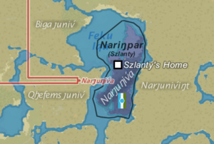
[[File:Ung-nar-map.png|thumb|alt=Nariŋpar as seen in earlier editions of the UNg Map|Nariŋpar as seen in earlier editions of the UNg Map]] | [[File:Ung-nar-map.png|thumb|alt=Nariŋpar as seen in earlier editions of the UNg Map|Nariŋpar as seen in earlier editions of the UNg Map]] | ||
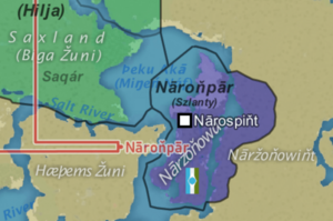
[[File:Screenshot 2024-05-15 142818.png|thumb|alt=Nariŋpar as seen in the latest edition of the UNg Map|Nariŋpar as seen in the latest edition of the UNg Map]] | [[File:Screenshot 2024-05-15 142818.png|thumb|alt=Nariŋpar as seen in the latest edition of the UNg Map|Nariŋpar as seen in the latest edition of the UNg Map]] | ||
[[Category:Country]] | [[Category:Country]] | ||
Revision as of 03:38, 29 May 2024
| The Isle of Nāroňpār Nāroňpār | ||||
|---|---|---|---|---|
| UŊ member | ||||
| ||||
 Map of Nariŋpar | ||||
| Capital city | Nārospiňt | |||
| Demonym | Nariŋpari | |||
| Dictator | ßlanty | |||
| Official languages | Isle Narkevin West Narkevin (regional) East Narkevin (regional) English | |||
Nariŋpar /naʁˈiŋ.paʁ/ or Nāroňpār (Isle Narkevin: Nāroňpār [ˈnaːr.oŋˌpaːr], West & East Narkevin: Nayïŋpay [naɣ.ˈɨŋˌpaɣ]), officially The Isle of Nāroňpār, is a country on the island of Narȷuƞiv́a/Nāržoňowa to the East of the Fequ Iqa/Þeku Āka & Yuɱa, south of Myžariky, & southeast of Þunan Qumreá's Saqár Province.


