File:Ung-members-map.png

Size of this preview: 599 × 599 pixels. Other resolutions: 2,047 × 2,048 pixels | 4,995 × 4,998 pixels.
Original file (4,995 × 4,998 pixels, file size: 3.13 MB, MIME type: image/png)
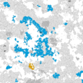
Map of UNg member states
File history
Click on a date/time to view the file as it appeared at that time.
| Date/Time | Thumbnail | Dimensions | User | Comment | |
|---|---|---|---|---|---|
| current | 01:05, 22 November 2024 |  | 4,995 × 4,998 (3.13 MB) | Zendrid (talk | contribs) | |
| 21:52, 8 September 2024 |  | 4,995 × 4,998 (3 MB) | Zendrid (talk | contribs) | new members Corneria and East Pua | |
| 23:07, 9 August 2024 |  | 4,995 × 4,998 (2.99 MB) | Zendrid (talk | contribs) | new members - Oberia, Tanylezi, Port Fin and ROM | |
| 00:31, 4 August 2024 |  | 4,995 × 4,998 (3 MB) | Zendrid (talk | contribs) | Port Fin now independent and applying for membership | |
| 22:50, 2 August 2024 |  | 4,995 × 4,998 (2.99 MB) | Zendrid (talk | contribs) | fixed Myzhariky-Fishland border and added more prospective members | |
| 14:52, 31 July 2024 |  | 4,995 × 4,998 (2.99 MB) | Sheikah (talk | contribs) | replaced map with zendrid's | |
| 02:01, 30 July 2024 |  | 2,497 × 2,497 (1.1 MB) | Sheikah (talk | contribs) | ||
| 01:49, 30 July 2024 |  | 2,497 × 2,497 (1.05 MB) | Sheikah (talk | contribs) | ||
| 23:40, 29 July 2024 |  | 2,497 × 2,497 (1.09 MB) | Sheikah (talk | contribs) |
You cannot overwrite this file.
File usage
The following 2 pages use this file: