Thasusa By Land Initiative: Difference between revisions
Jump to navigation
Jump to search
mNo edit summary |
No edit summary |
||
| (35 intermediate revisions by 8 users not shown) | |||
| Line 1: | Line 1: | ||
The "'''Thasusa By Land'''" Initiative is an international cooperation initiative between the nations of the continent of [[Thasusa]] to create a network of roads for foot and horse travel. It was announced by Bezuv [[Agamashuya I]] of [[Xarslasja]] and, as of November 28th, 2024, has gained the support of [[Cenroad]]. | [[File:Thasusa by land.png|thumb|Logo for the Thasusa By Land Initiative, showing the continent of Thasusa covered by a web.]] | ||
[[File:Tbli-map.png|thumb|alt=probably inaccurate map of all TBLI roads|Map of all TBLI roads, with areas not up to code signified by cutoffs.]] | |||
The "'''Thasusa By Land'''" Initiative (Arodjun: ''Eirax '''Tasussja Mo Fixwau''''') is an international cooperation initiative between the nations of the continent of [[Thasusa]] to create a network of roads for foot and horse travel. It was announced by Bezuv [[Agamashuya I]] of [[Xarslasja]] and, as of November 28th, 2024, has gained the support of [[Cenroad]]. | |||
== Participating | == Participating ŋations == | ||
* [[Xarslasja]] (lead proponent) | * [[Xarslasja]] (lead proponent) | ||
* [[Kingdom of Kyaw Cen]] | * [[Kingdom of Kyaw Cen]] | ||
* [[ | * [[Pua]] | ||
* [[ | * [[Pihi]] | ||
* [[Enkavak]] | |||
* [[Aylongam]] | |||
* [[Keltechra]] (ostensibly) | |||
* [[Nāroňpār]] | |||
* [[Myžariky]] | |||
Several ŋations participated before their dissolution: | |||
* [[Þunan Qumreá]] | |||
* [[Fishland]] | |||
* [[West Pua]] (now Pua) | |||
== Participating companies == | |||
* [[Cenroad]] | |||
== Naming Scheme == | == Naming Scheme == | ||
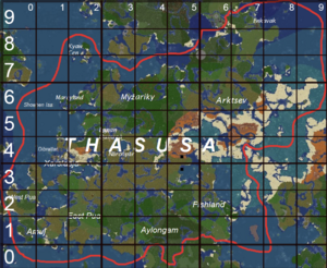
[[File:Thasusa Road Grid.png|thumb|This map shows what number in the tens place each TBL-approved road should have. Large numbers listed vertically denote the tens place of east-west roads; small numbers listed horizontally denote the tens place of primarily north-south roads.]] | |||
The road labeling scheme proposed by Agamashuya is as follows, as inspired by the United States Interstate System in real life: | The road labeling scheme proposed by Agamashuya is as follows, as inspired by the United States Interstate System in real life: | ||
* Roads whose net displacement is mostly on the east-west (x) axis end with even numbers, with numbers as low as 0 at the furthest south and as high as 98 at the furthest north | * Roads whose net displacement is mostly on the east-west (x) axis end with even numbers, with numbers as low as 0 at the furthest south and as high as 98 at the furthest north | ||
** The guideline image shows the recommended tens place for east-west (x) axis roads on the left side. For example, an east-west road whose westernmost point is in southern Xarslasja should have a road with a number in the 30's or 40's which ends in an EVEN number. (ie. 30, 34, 48, etc.) | |||
* Roads whose net displacement is mostly on the north-south (y) axis end with odd numbers, with numbers as low as 1 at the furthest west and as high as 99 at the furthest east | * Roads whose net displacement is mostly on the north-south (y) axis end with odd numbers, with numbers as low as 1 at the furthest west and as high as 99 at the furthest east | ||
** The guideline image shows the recommended tens place for north-south (y) axis roads on the top. For example, a north-south road whose northernmost point is in [[Myžariky]] should have a road with a number in the 30's, 40's, or possibly 50's, which ends in an ODD number. (ie. 31, 47, 59, etc.) | |||
* X axis roads begin with a letter associated with the nation or city at their furthest west point | * X axis roads begin with a letter associated with the nation or city at their furthest west point | ||
* Y axis roads begin with a letter associated with the nation or city at their furthest north point | * Y axis roads begin with a letter associated with the nation or city at their furthest north point | ||
| Line 31: | Line 50: | ||
* [[Imerchal]] plans to extend the initiative through [[Pòjaj]] | * [[Imerchal]] plans to extend the initiative through [[Pòjaj]] | ||
* [[Coldba (Cuba)]] also plans to extend the [[Freezeway]] network from Pòjaj, through Murbetia Basin, North Mountains, Sprutia, and Arctic Circle Counties, ending in [[Old Cuba]]. | * [[Coldba (Cuba)]] also plans to extend the [[Freezeway]] network from Pòjaj, through Murbetia Basin, North Mountains, Sprutia, and Arctic Circle Counties, ending in [[Old Cuba]]. | ||
== Timeline == | |||
* November 2024: The Initiative is announced and several countries sign on, or at least suggest interest. | |||
* December 2024: Several existing roads are declared compatible for the Initiative's scheming system. | |||
* January 2025: The first new international bridge is completed, connecting [[Xarslasja]] to [[Nāroňpār]] over the [[Salt River]]. Soon after, several other bridges are built connecting Xarslasja to both [[East Pua]] and [[West Pua]]. [[Fin]] sets up a system to track applicable roads. | |||
* April 2025: Puan leader [[Peaches]] approves a Xarslasja-managed road construction plan in Puan territory, with the intention of connecting Sun City West to Bumblebee to Naronpar, and San Tan Valley to Nogales and Kanga. | |||
* April 2025: The San Tan Freeway has its first stretches completed, and earns the official TBL code "X30," showing that it is a road that begins in Xarslasja (X), approximately 30% north of the southernmost point in Thasusa (3), and that the road is mostly east to west (0). | |||
* June 2025: The network of existing roads is examined and applicable ones are added to the official list of TBL roads. Agamashuya I resumes progress on roads connecting Pua to Xarslasja. | |||
* July 2025: [[Pihi]] is connected to the TBL network with the Pihiway, which starts at a junction with the P21 to Pfoas. | |||
* October 2025: The P10 Pihiway makes its way into [[Aylongam]] and connects to the Iron Farm near [[Khaath Tran]]. In Ngerlin, a glass-made underwater tunnel begins construction, setting the P10 on a path to eventually connect to [[Pòjaj]]. | |||
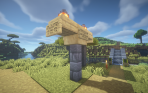
[[File:TBL Signpost 1.png|thumb|A typical TBL signpost, stating "THASUSA BY LAND," followed by the route code, followed by the route name, followed by the country that the sign is located in.]] | |||
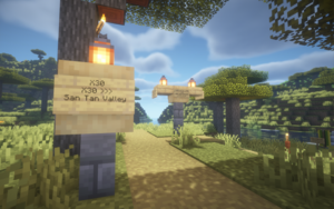
[[File:TBL Small Post.png|thumb|A small TBL post, stating the current route code, along with pertinent directions to help travelers stay on track.]] | |||
== Roads == | |||
* East-West: | |||
** P10: Pihiway ([[Pua]], [[Pihi]], [[Aylongam]]) | |||
** P20: Ŋautobahn ([[Pua]]) | |||
** P28: Allium Loop ([[Pua]]) | |||
** X30: San Tan Freeway ([[Xarslasja]], [[Pua]], [[Nāroňpār]]) | |||
** X40: Xarslasja Highway ([[Xarslasja]], [[Nāroňpār]]) | |||
** X42: Carefree Highway ([[Xarslasja]], [[Ŋibraltar]]) | |||
** Þ50: Lighthouse Road ([[Þunan Qumreá]]) | |||
** M60: Spawn Road (Myžariky) | |||
** M66: Name TBD ([[Myžariky]]) | |||
* North-South: | |||
** P15: Nguhrovisual Road (TBD) ([[Pua]]) | |||
** X19: Greenway Road ([[Xarslasja]]) | |||
** P21: Kanga Road ([[Pua]]) | |||
** M25: Ashway ([[Myžariky]], [[Tanzang]], [[Þunan Qumreá]], [[Xarslasja]]) | |||
** X29: Beeline Highway ([[Xarslasja]]) | |||
** N33: Name TBD ([[Nāroňpār]]) | |||
** Þ35: Name TBD ([[Þunan Qumreá]], [[Nāroňpār]]) | |||
== See also == | |||
* [[Chaos by Land Initiative]] | |||
* [[GHaST Network]] | |||
Latest revision as of 15:39, 17 December 2025


The "Thasusa By Land" Initiative (Arodjun: Eirax Tasussja Mo Fixwau) is an international cooperation initiative between the nations of the continent of Thasusa to create a network of roads for foot and horse travel. It was announced by Bezuv Agamashuya I of Xarslasja and, as of November 28th, 2024, has gained the support of Cenroad.
Participating ŋations
- Xarslasja (lead proponent)
- Kingdom of Kyaw Cen
- Pua
- Pihi
- Enkavak
- Aylongam
- Keltechra (ostensibly)
- Nāroňpār
- Myžariky
Several ŋations participated before their dissolution:
- Þunan Qumreá
- Fishland
- West Pua (now Pua)
Participating companies
Naming Scheme

The road labeling scheme proposed by Agamashuya is as follows, as inspired by the United States Interstate System in real life:
- Roads whose net displacement is mostly on the east-west (x) axis end with even numbers, with numbers as low as 0 at the furthest south and as high as 98 at the furthest north
- The guideline image shows the recommended tens place for east-west (x) axis roads on the left side. For example, an east-west road whose westernmost point is in southern Xarslasja should have a road with a number in the 30's or 40's which ends in an EVEN number. (ie. 30, 34, 48, etc.)
- Roads whose net displacement is mostly on the north-south (y) axis end with odd numbers, with numbers as low as 1 at the furthest west and as high as 99 at the furthest east
- The guideline image shows the recommended tens place for north-south (y) axis roads on the top. For example, a north-south road whose northernmost point is in Myžariky should have a road with a number in the 30's, 40's, or possibly 50's, which ends in an ODD number. (ie. 31, 47, 59, etc.)
- X axis roads begin with a letter associated with the nation or city at their furthest west point
- Y axis roads begin with a letter associated with the nation or city at their furthest north point
- Each road also has a "full name" as chosen by its primary builders
Rules for Official Status
- The road should be passable by foot and by horse, and at least 90% on the surface
- Any tunnels must be tall enough for horses to pass through safely
- The road should be well-lit enough to be largely safe from monsters
- The road should be at least two blocks thick at all times and free of potholes or other obstructions
- With the permission of a local government, a road whose planned route approaches a town, city, or naturally-generated village, should pass through that settlement
Coordinating Projects
- Imerchal plans to extend the initiative through Pòjaj
- Coldba (Cuba) also plans to extend the Freezeway network from Pòjaj, through Murbetia Basin, North Mountains, Sprutia, and Arctic Circle Counties, ending in Old Cuba.
Timeline
- November 2024: The Initiative is announced and several countries sign on, or at least suggest interest.
- December 2024: Several existing roads are declared compatible for the Initiative's scheming system.
- January 2025: The first new international bridge is completed, connecting Xarslasja to Nāroňpār over the Salt River. Soon after, several other bridges are built connecting Xarslasja to both East Pua and West Pua. Fin sets up a system to track applicable roads.
- April 2025: Puan leader Peaches approves a Xarslasja-managed road construction plan in Puan territory, with the intention of connecting Sun City West to Bumblebee to Naronpar, and San Tan Valley to Nogales and Kanga.
- April 2025: The San Tan Freeway has its first stretches completed, and earns the official TBL code "X30," showing that it is a road that begins in Xarslasja (X), approximately 30% north of the southernmost point in Thasusa (3), and that the road is mostly east to west (0).
- June 2025: The network of existing roads is examined and applicable ones are added to the official list of TBL roads. Agamashuya I resumes progress on roads connecting Pua to Xarslasja.
- July 2025: Pihi is connected to the TBL network with the Pihiway, which starts at a junction with the P21 to Pfoas.
- October 2025: The P10 Pihiway makes its way into Aylongam and connects to the Iron Farm near Khaath Tran. In Ngerlin, a glass-made underwater tunnel begins construction, setting the P10 on a path to eventually connect to Pòjaj.


Roads
- East-West:
- P10: Pihiway (Pua, Pihi, Aylongam)
- P20: Ŋautobahn (Pua)
- P28: Allium Loop (Pua)
- X30: San Tan Freeway (Xarslasja, Pua, Nāroňpār)
- X40: Xarslasja Highway (Xarslasja, Nāroňpār)
- X42: Carefree Highway (Xarslasja, Ŋibraltar)
- Þ50: Lighthouse Road (Þunan Qumreá)
- M60: Spawn Road (Myžariky)
- M66: Name TBD (Myžariky)
- North-South: